After a long and unexpected hiatus, Ben Wanderin’ is returning.
This blog has always been an excuse for me to write. It serves no existential purpose beyond getting words out of my head and onto your screens. As such, new posts only happen when I feel like writing them. And honestly, I haven’t felt much like writing in recent years. Recently, though, I’ve been reminded that writing is my only real superpower. It is the means through which I can help (in whatever minuscule way) the world and its inhabitants maintain sanity in an otherwise insane period in history. So I’m going to go for it… and you’re invited along again.
I have a lot of content almost ready to be posted… including thoughts from my John Muir Trail walk in July 2025, the excitement of following a mountain lion for days in Utah’s Canyonlands, and more.
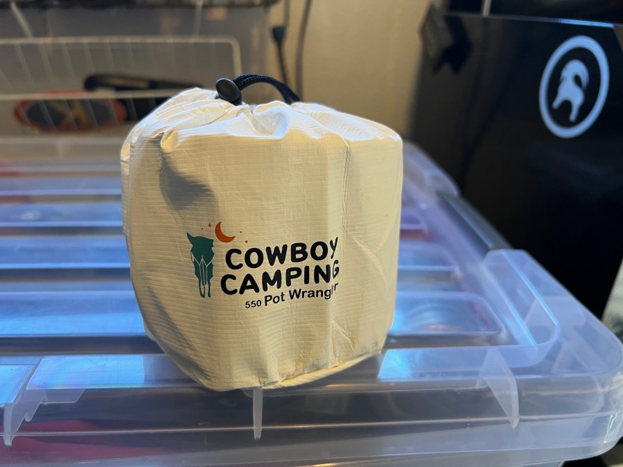
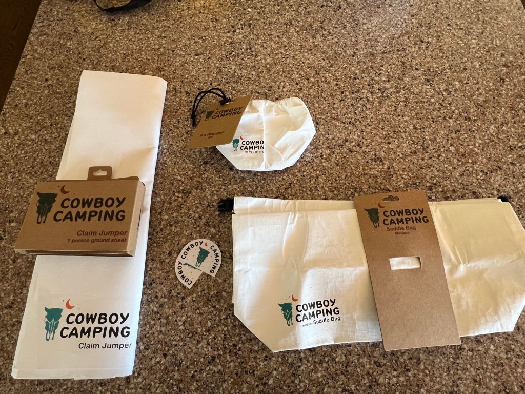
But we’ll start with a good ol’ gear review. The folks at Minimal Gear (makers of thru-hiker favorite CNOC hydration accessories) have kindly sent me a batch of goodies from their brand new Cowboy Camping line. With our traditional spring Utah trip fast approaching, I’ll have an opportunity to put these accessories through the red dirt ringer. Here’s a short preview.
Minimal Gear’sCowboy Camping sub-brand offers ultralight backpacking accessories made from flashspun HDPE fabrics. Most of us have already used flashspun HDPE in the form of Tyvek groundsheets. Rather than repurposing home wrap Tyvek (which can be heavy, bulky and crinkly when new), hikers can now use a range of products made from carefully chosen flashspun HDPE in appropriate weights and thicknesses.
According to Minimal Gear, this variation in flashspun HDPE fabrics is what makes Cowboy Gear products feasible. “After years of proving itself in the field as a groundsheet and as material for accessories like stuff sacks and bags,” the company says, “flashspun HDPE… fit the bill. This material comes in various weights and textures; it can feel solid like paper or be bonded and have a soft in-hand feel like most fabrics.”
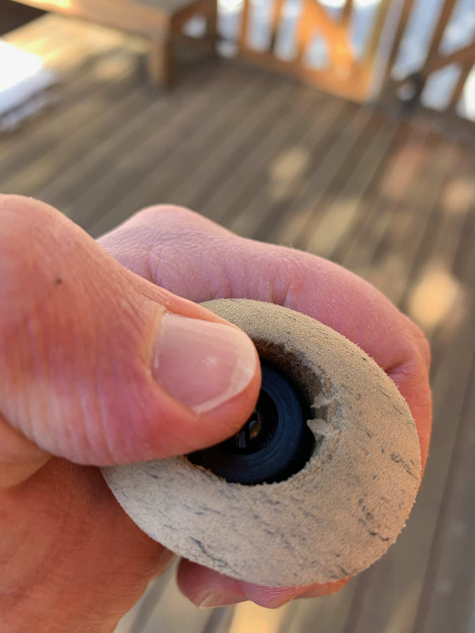
Three items from Minimal Gear’s Cowboy Camping line: Claim Jumper groundsheet, Pot Wrangler cookpot sack, and Saddle Bag roll-top sack.
My initial reaction confirms this statement. The Claim Jumper groundsheet is similar to the “kite Tyvek” I typically buy from Boulder’s iconic Into The Wind kite shop, though perhaps with an improved nap. The Saddle Bag and Pot Wrangler have a different feel to them… smooth and soft, with an ease of use that previously required multiple Tyvek washings.
All three items fill a need within my UL quiver. I’ve been looking for an upgraded groundcloth solution that didn’t cost as much as the fancy options offered by ultralight tent makers. Finding an appropriately sized stuff sack for clothes and shoulder season layers is always a challenge. And I’m glad to finally be able to throw away the dismal carrying sack Toaks ships with its pots.
The next time you see this gear, its pearly white gleam will have been replaced by the permanent reddish orange stain that can only come from Utah dirt. I’m excited to see how it performs in the field.
Much, much more to come in the weeks ahead. But I’m sure happy to be back!
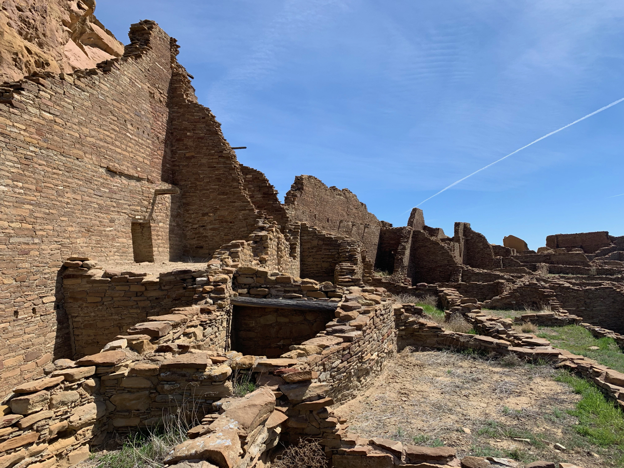
We’d been meaning to get back to Chaco Culture Natural Historic Park for a long, long time. Julie and I had first visited in the late 1990s, when Julie’s sister Meredith (who lived in Arizona at the time) met us at Chaco to camp and explore. I’ve seen a lot more of Four Corners country since then, of course, and I was excited to see how the splendid architecture and natural beauty of Chaco would compare to my favorite places in the slickrock world.
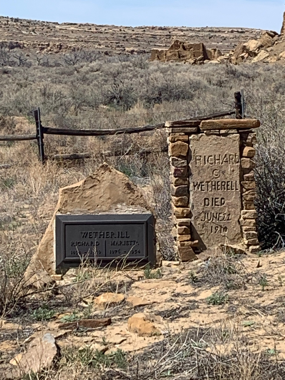
Pueblo Bonito, where Richard Wetherill ran a trading post and met an untimely demise
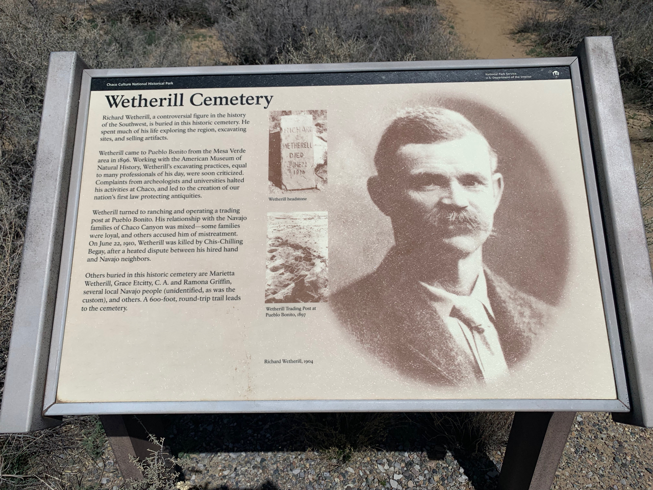
I was suprised, however, that the park “attraction” with which I was most smitten was not the massive ruin of Pueblo Bonito, nor the imposing figure of Fajada Butte standing alone in the sagebrush, nor any of the various examples of Ancestral Puebloan rock art that can be found in various locations around the park. No, I was most interested in Richard Wetherill’s grave.
One of four brothers in the foremost family of early Four Corners archaeology, Richard Wetherill remains a controversial figure. Wetherill’s various and wide-ranging discoveries—including Cliff Palace at Mesa Verde, Keet Seel, Betatakin and many others—is surely the most impressive list of any of the first wave of desert explorers. Yet he is typically derided as a “pot hunter” whose lack of archaeological training and willingness to profit from the sale of the artifacts he discovered outweigh his findings.
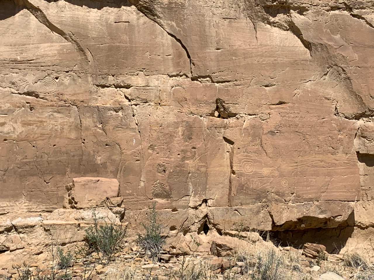
Rock art near Pueblo Bonito is subtle and only reveals itself with careful viewing
What makes Richard Wetherill’s list of accomplishments more impressive is that they were all achieved in a relatively short period of time—just barely more than 50 years—in a life cut short by a bullet. Wetherill was shot dead by a local Navajo man at his trading post at Pueblo Bonito in June of 1910—just thirteen seasons after his beloved Chaco Canyon region was proclaimed as a national monument by President Theodore Roosevelt.
Despite the prominent signage provided by the Park Service, Wetherill’s grave itself is off limits to casual viewers. A ragged fence of sagging timbers, rusted barbed wire and mismatched sections of gate prevents curious onlookers from coming within thirty feet of Wetherill’s two headstones—one with rustic hand-carved lettering and adorned with stacked stones in roughly Chacoan style, the other (shared with his wife, Marietta) strangely generic.
The graves of Richard and Marietta Wetherill, just south of Pueblo Bonito
Curiously, “Wetherill’s Grave” contains more than just the remnants of Richard and Marietta, who outlived her murdered spouse by forty-some years. Also interred there are, according to the park’s ubiquitous, sun-bleached NPS signage, are “Grace Etcitty, C. A. and Ramona Griffin, several local Navajo people (unidentified, as was the custom), and others.” One can see vague suggestions of gravesites in the circled stones and rounded mounds of dirt within the haggard fence, though the exact locations and identities of the “local Navajo people” and “others” remains elusive.
A partial answer to the eternal question of “who’s buried at Wetherill’s Tomb?”
As a longtime enthusiast of the natural wonders of the Colorado Plateau, I’ve frequently come across references to the Wetherill family in the field and in various books on the archaeology of the region. There are Wetherill Mesas in both Mesa Verde National Park and just south of the Arizona-Utah state line in Monument Valley. So it shouldn’t have surprised me that Ricard’s final resting place held such prominence in modern-day Chaco Park.
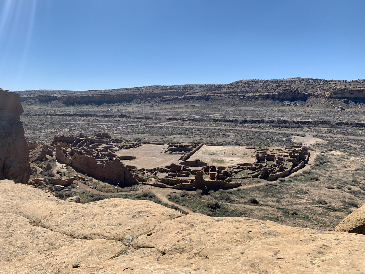
And what prominence! Julie, Colin and myself first visited the Wetherill Grave as a twenty-minute deviation from exploring the connecting chambers and great kivas of Pubelo Bonito. The next day, we encountered the NPS placard pictured above while registering for our dayhike to Pueblo Alto, a partially excavated site with potsherds scattered about and a commanding view of the surrounding mesas and valleys. And we had a prime view of the gravesite itself from the Pueblo Alto loop trail. It seemed to me that one could not escape Wetherill (and the site of his burial) anyone one went in Chaco—perhaps fittingly, given the importance and infamy of Richard Wetherill to that place a century ago.
Looking down on Pueblo Bonito from the overlook along the Pueblo Alto loop trail
From the Pueblo Bonito overlook on the shade-providing rim to the west, one can easily imagine Richard and Marietta’s Chaco trading post, which they’d literally carved into the remnants of the pueblo in pre-Park Service days. Eyes closed in the springtime desert sun, I could see them going about the daily business of running the most remote outpost in the desert southwest. Bartering good-naturedly with Navajos whom they considered friends. Keeping a careful inventory of sugar, coffee, horseshoes, jerky and more. Watering their stock in the draw below. Subsisting and surviving, if not exactly thriving.
The overlook above Pueblo Bonito is extremely popular with visitors to Chaco, and for good reasons. But I suspect that many viewers of the ruins below cannot help but move their gaze briefly to the lonely little fenced graveyard situated just to the south.
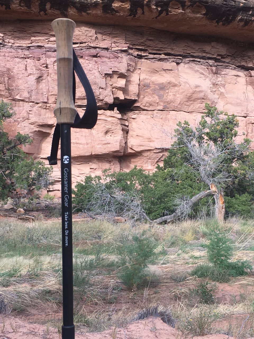
I was recently given the opportunity to test-drive one of the top trekking pole models on the market today: the Gossamer Gear LT5 carbon poles (MSRP $195.00). The GG poles accompanied me on numerous dayhikes and one memorable backpack into the Needles District of Canyonlands National Park, the highs and lows of which I’ve highlighted in a previous blog post.
Gossamer Gear LT5 Three Piece Carbon Trekking Pole
A relative latecomer to the use of poles for backpacking (my knees requested help around age 40), I’d been using the economical, Massdrop-backed Fizan Compact Poles for a couple years. As one would expect, the Gossamer poles were certainly a step up in terms of performance and quality! Here are some specs provided by the manufacturer.
Weight
Pole with strap and basket – 5.3 oz / 150 g
Pole – 4.6 oz / 130 g
Strap and screw – .4 oz / 12 g
Basket – .3 oz / 8 g
Adjust from
23.5″ / 60 cm when closed to 51″ 130 cm when fully extended for hiking
Section Lengths
Top section 19.5″ / 49.53 cm
Middle section 19.25″ / 48.98 cm
Tip section 18.75″ / 47.62 cm
This evaluation will focus on four distinct areas: initial impressions, use during walking, use as a pole for ultralight structures, and a direct comparison with the ubiquitous Fizan Compact trekking poles.
Initial impressions
Upon removal from the box, it’s clear that these poles are a step up from the Fizan Compacts I’ve been using in terms of quality of materials and craftsmanship. These poles are obviously well designed and well constructed, which is comforting to users who expect quality at this price point.
Use during walking
The adjustment straps are truly first class! They are easy to adjust, stay in place once adjusted, and are comfortable in both the material used and the placement of the adjustment buckle. My favorite adjustment system of any set of poles I’ve used.
On my first dayhike, I immediately noticed that the handles basically require two fingers above “the bump” instead of one. I am generally accustomed to hiking with one finger above the bump, but I was able to make the transition without too much trouble. Some hikers may not find this to be a problem, while others may not find a finger placement that is comfortable for them.
LT5 hand placement. Thumb on top and two fingers above the bump!
In addition to their unusual size, the handles get softer with use—both during a hike and over time and multiple outings. As a result, my thumbs eventually make contact with the screw at the top. I did find this somewhat distracting and would recommend that Gossamer Gear consider a somewhat more rigid material towards the top of the handle to accommodate us thumbs-on-top folks.
One for the thumb! Soft handle material makes the top screw a constant companion.
Some lightweight poles have a tendency to “whip” during the stride, perhaps due to a lack of stability in materials. I find the whip-like feeling to be distracting while walking. These poles do not exhibit the dreaded whip effect! The baskets are slightly larger than average and did seem to catch on rocks and plants somewhat more often than poles with smaller baskets.
I did notice that the twist-lock mechanisms on these three-piece poles had a tendency to loosen with use. This was surprising at first, but I quickly adopted a habit of tightening both poles whenever I sat down for a breather. Problem solved.
Use as pole(s) for ultralight structures
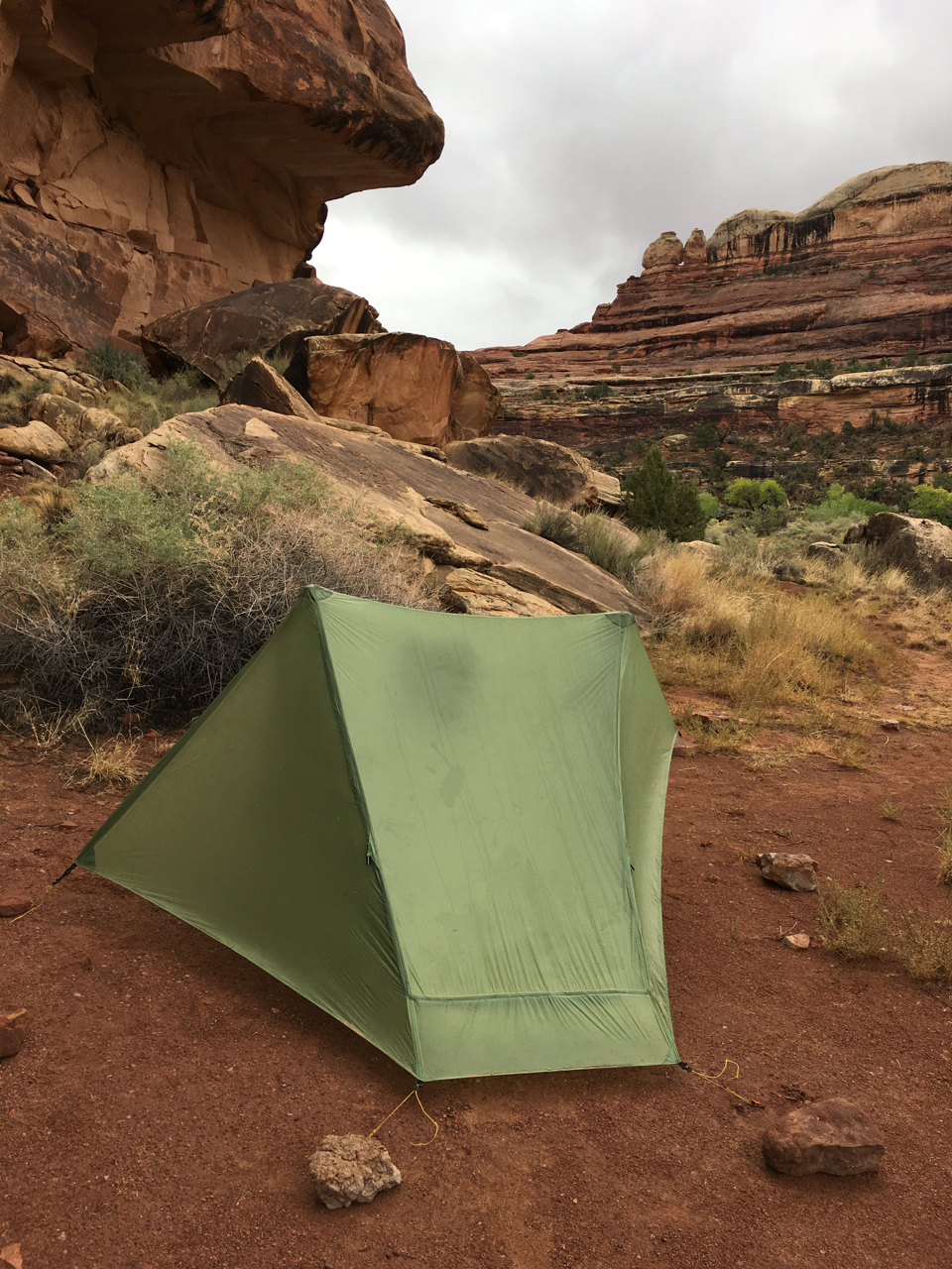
The LT5 proved to be excellent poles for use with an ultralight shelter—in my case, an early 2018 model Gossamer Gear The One. I encountered no difficulty getting the exact pitch I wanted with these poles.
Gossamer Gear The One with asymmetrical pitch
As mentioned before, the LT5 do not have the strongest twist-lock mechanism I’ve encountered. While this is a slight negative for walking, it’s just fine for those of us who like to experiment with a variety of different pitching strategies for our shelters. Even after a long day of desert hiking, the twist-lock did not freeze up or prove difficult to loosen. In this photo, I pitched The One with one larger pole and one shorter pole to provide extra vestibule room to help me through a storm-filled Utah day. The poles allowed such a pitch with no quarrel.
Comparison with Fizan Compact poles
Here are a few direct comparisons with my previous go-to trekking poles, the Massdrop-exclusive version of Fizan Compact poles. If a subject is not specifically addressed in the bullets below, it is because there was not a significant difference between the two types of poles.
LT5 hand straps are much more comfortable and do not have the exposed and potentially scratchy threads found on the Fizan. Winner: LT5.
LT5 hand strap adjustability is much more convenient than the Fizan. Winner: LT5.
Fizan has smaller, closed baskets, which are less likely to momentarily catch on rocks than the LT5. Winner: Fizan.
LT5 was much more likely to inadvertently collapse due to weakness of the tightening mechanism. Winner: Fizan.
LT5 did not exhibit the “ultralight pole whip” feeling from which the Fizan sometimes suffer. Winner: LT5.
In conclusion, I’d strongly recommend the Gossamer Gear LT5 poles based on their superior performance while in use. I did have a few minor quibbles that required some mental adjustments on my part, but once I got on the trail those issues were quickly forgotten.
Author’s note. The poles described in this post were provided by the manufacturer at no charge for the purpose of testing and review. The thoughts and conclusions above are strictly mine and were not influenced by the manufacturer in any way.
Backcountry trips with multiple parties are hard to plan—and even harder to cancel.
My first mistake was scheduling back-to-back excursions during shoulder season on the Colorado Plateau. After a hot summer and (to that point) a mild fall with little to no precipitation, it was only a matter of time until the weather (and my plans) changed. And change they did… for both trips.
Gatlin and I had been watching the forecast for weeks before the trips were scheduled to begin. We knew that getting to our planned destination—Dark Canyon Wilderness, way way way back of beyond in southeastern Utah—would require a stroke of early October luck when it came to weather. When we arrived at our usual motel in Monticello, UT on Sunday night, we were greeted by a mean grey sky and temperatures hovering around freezing.
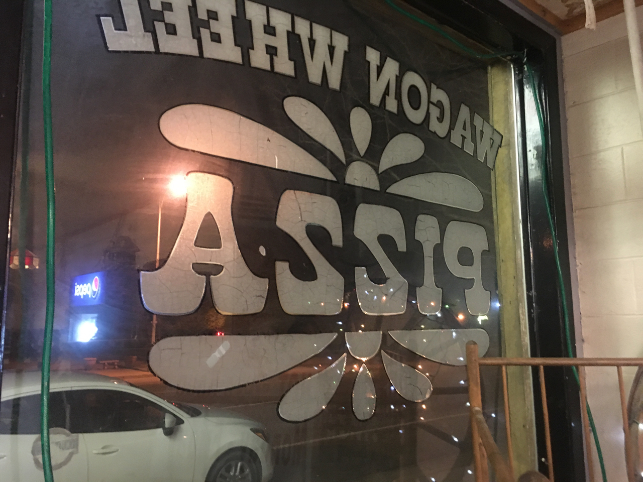
Pizza joint in Monticello. Dubbed “Ass19” by my eight year old.
Now, the problem wasn’t really the weather per se. We had the right gear to handle the cold, and we’ve gotten soaked many times during stormy Colorado summers. The problem was trailhead access. To call the network of Forest Service and BLM tracks that access Dark Canyon “dirt roads” is oversimplification. Most of the route is made of Bentonite clay, a rust-colored soil with the consistency of overcooked steel-cut oats when wet. To drive in truck-swallowing bentonite is to drive perpetually sideways, as the consistency of the clay somehow prevents one from going straight ahead. The steering wheel is always at 3 or 9, never at 12.
Fortunately, Gatlin had thought ahead and booked a backup permit. Instead of testing our driving mettle getting back to Dark Canyon, we’d be spending a comparatively civilized few days off trail in an at-large zone in Canyonlands National Park. When we woke up on hike-in day to several inches of snow on our windshields, we knew bailing on Dark Canyon was the smartest move. And it was an easy decision. There was no agonizing, no gnashing of teeth. On to Plan B.
We stopped at the Peace Tree in Monticello (the preferable Peace Tree location, for my money) for our customary day-of-trip breakfast: tasty breakfast burritos on whole wheat tortillas and lots of dark roast coffee. On our way out, we struck up a conversation with a man, a local who’d tossed down a cleaning rag before coming out of the kitchen at the end of a shift. He asked where we were going. “We’d been planning on heading into Dark Canyon,” Gatlin replied.
“It hadn’t rained in nearly a year, and in the last week we’ve gotten that year’s worth of rain,” the man gravely stated. “You get back on those roads and you’ll never get out.”
“Yeah, we know,” I assured him. “We’re considering other options. Thinking of just going into Needles instead.”
He shook his head slightly and headed for the door. “I know you’ll make the right decision. Good luck.”
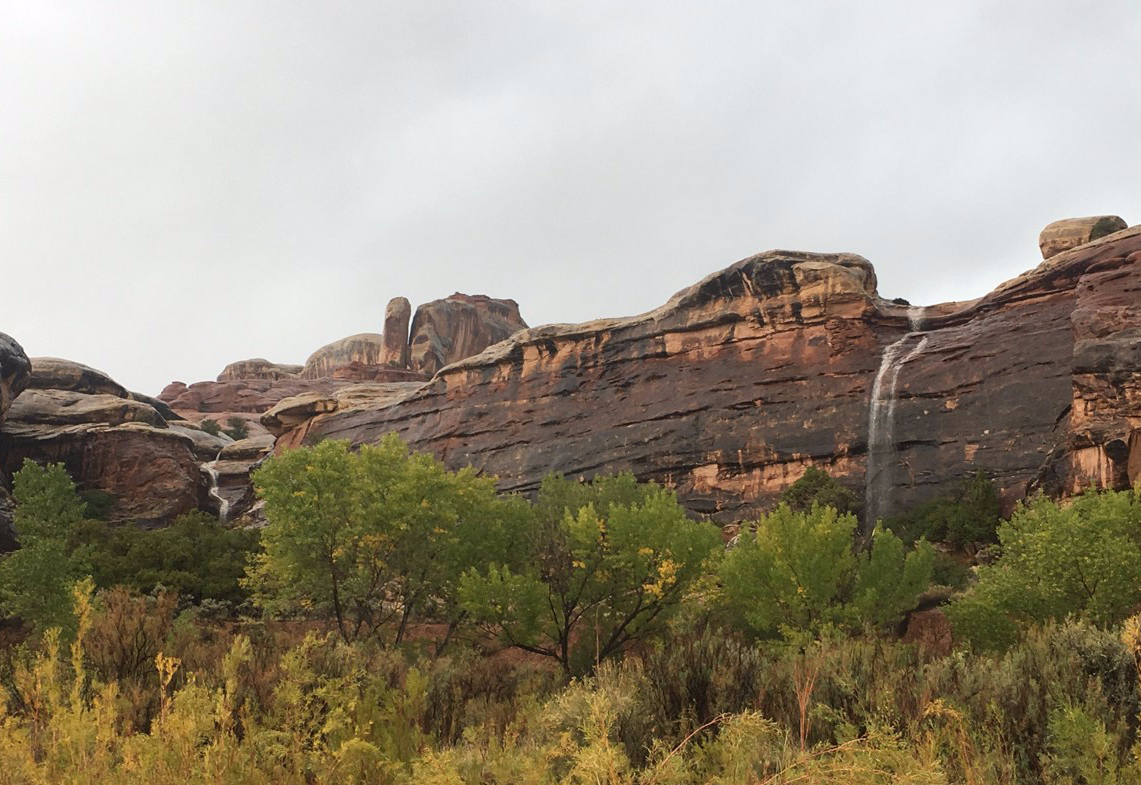
Dormant pour offs suddenly come to life after days of rain
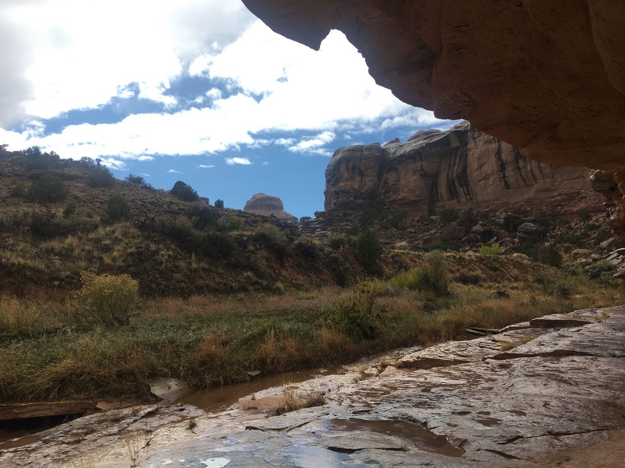
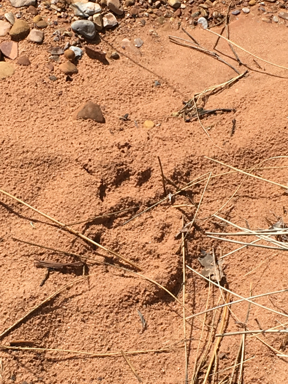
And “the right decision” it was. Instead of battling the bentonite for the rest of the day, we made the easy hour-long drive to the Needles Visitor Center. Of course, the backup plan itself was not without challenges of its own. We spent four days getting soaked and drying out, including one memorable afternoon and night spent at Peekaboo Spring watching every sandstone pour off run, water traveling millions of years of geologic time in seconds and crashing to the ground. We thrashed through willows and scrambled along deer paths to avoid more willows, marveling all the while at the mountain lion tracks that accompanied us even in the smallest drainages. At one point, we climbed up and out of a side canyon when the roaring of the creek became louder than our conversation. Fortunately, the flash flood we feared never materialized.
As the clouds part, dry streams run again
The hike out was a pure soaker. I had water in places I didn’t know it could go. Gatlin and I covered six-plus miles of both off-trail and on-trail hiking in fewer than three hours. Not bad…especially compared to the red-mud horrors that would have awaited us had we stuck with the original plan. We changed into dry clothes at the Needles Visitor Center, said our goodbyes for a few months and headed in opposite directions: him south to Arizona, me north to Colorado.
Making tracks… this cat and ourselves
As soon as I made it to US 191 and turned left towards Moab, my thoughts shifted to my second trip: four days floating the Colorado River between Fruita, CO and Westwater, UT. We’d done the fabled “Ruby Horsethief” float the previous fall, and I’d been looking forward to it for months. I powered up my phone to tell Julie that I’d made it out safely. But before I could call, I noticed a string of text messages and emails. Never a good way to return to civilization…
“Check your email,” read one text from Julie. “The Rutledges are out for the river.”
That wasn’t what I was expecting to hear. Once I got close enough to Moab to make a call, I dialed Julie to get the scoop. While I’d been backpacking in the rain (and looking forward to a dry second trip), the forecast had changed. Highs were now dramatically lower, with daytime highs in the 30s and nighttime lows well below freezing. A classic Colorado River wind out of the northwest at 20 miles per hour were sure to make it feel even colder. The most experienced boaters in our group, the Rutledges had gone from gung-ho to staying home because of the weather.
There was also the matter of the kids to consider. Ranging in ages from five to nine, the youngest members of our group would surely dislike rafting into a stiff headwind on a cloudy mid-30s day. As a firm believer in “banking good experiences” for kids, I strongly disliked the idea of my boy Colin forever associating rafting with cold, wet and windy days on the Colorado. And a wet Hypalon slip would raise the specter of hypothermia for all members of the group.
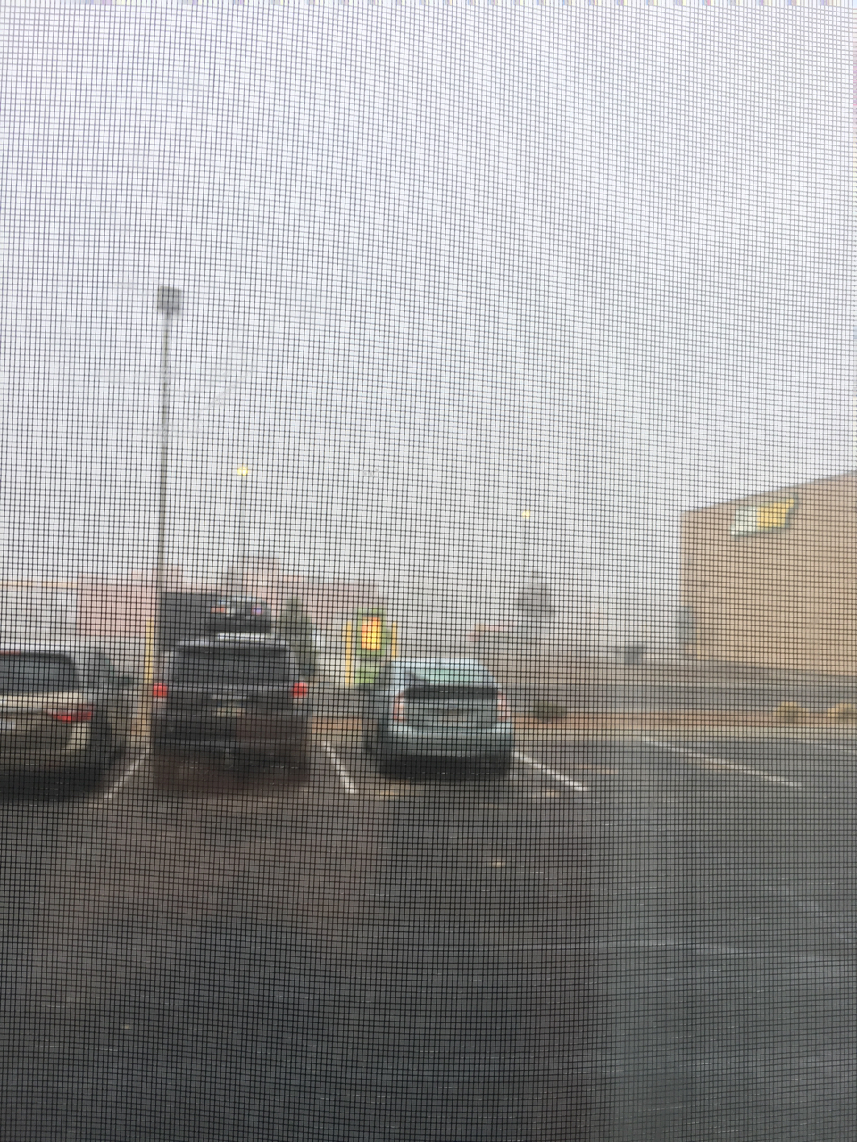
After an hour of Tecate-fueled deliberation at the Super 8 in Fruita, I came to my trip-leader senses. Ruby was off. Calls were made to announce the cancellation to all.
Super 8 = super foggy as I make the call. And the calls.
Where the trip with Gatlin was two dudes and two backpacks, the Ruby trip was six adults, four kids and three fourteen-foot rafts loaded with all the gear and beer we could muster. Changing plans with Gatlin required no psychological heavy lifting, as there’d been little or no effort to start with. But for Ruby, we’d meticulously planned launch days, campsites and mileages. We’d all cooked communal breakfasts and dinners—standard river practice. We’d all bought new gear, taken time off from work and paid to have our cars and trailers shuttled from the put-in at Fruita to the takeout at Westwater. We were invested. And now that investment was crashing.
Lamenting the loss of the last planned trip of 2018, I decided to hit my favorite Fruita joints. The early evening was cold and foggy—confirming the veracity of the forecast for once. A quick pint at the Copper Club went down with little impact. A calzone and a few IPAs at the Hot Tomato was a somewhat more effective salve, but it was going to take time to come to grips with the change of plans. I hated abandoning all that prep work. Hated being the trip leader who was responsible for making the call. Hated my overly cautious side, especially when there were kids involved.
As I was finishing up, a fifty-something woman took the bar stool next to me. She was talkative and outgoing in a way that I couldn’t emulate on my most charming days, much less on a dour Thursday like this. More beers flowed, and she revealed that she was a kayaker and had run the Ruby Horsethief section of the Colorado just a few weeks before.
“I was supposed to launch tomorrow,” I glumly revealed. “Six adults, four kids. Three nights. Got the permit months ago.”
“Kids? In this wind?” She was incredulous at the thought. “That’s a bullshit idea. They’d hate it. Hell, I hated it. I got so tired of battling the headwind that I tied in with a motorized group after the first day. That was totally the right call, man.”
I wander a lot, though not as much as I’d like. And I read a lot, though not as much as I should. These hobbies often collide, and it’s not unusual for me to recognize places I’ve been in the things I read. So when I saw Paige Blankenbuehler’s recent High Country News piece about the intersection of wildlife management and domestic sheep grazing in the Weminuche Wilderness of Colorado, it took me back to an evening in the far northern Weminuche in July of 2017. I didn’t think too much of it at the time, but in retrospect what I saw (and documented) that night tells a big part of the story of land management in the Colorado high country.
Brian (my usual hiking cohort) and I were about halfway through a weeklong trip from Weminuche Pass to Spring Creek Pass along Colorado’s Continental Divide Trail. We’d started the day at Kite Lake, where early-morning storms had kept us off the trail until late morning. The hike to Stony Pass was only eight or nine miles—a mild day compared to the rest of our itinerary—so we arrived mid-afternoon with plenty of time to relax.
We pitched our tents right below Stony Pass Road in a broad meadow filled with both wildflowers and mining-era detritus, including the battered remnants of some century-old cabins. OHV traffic on the Stony Pass road was mercifully light, perhaps due to the threatening clouds that had begun to gather again to the west. In spite of the gathering storm, we were hoping for a pleasant, low-key evening.
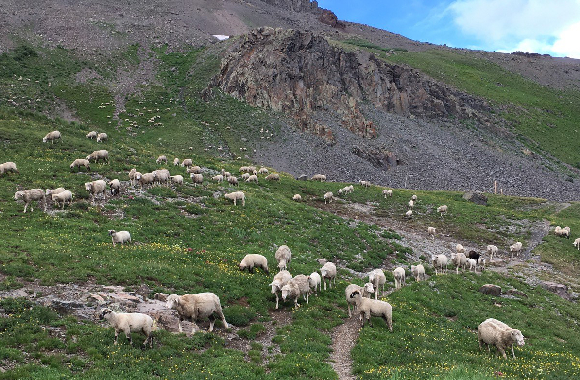
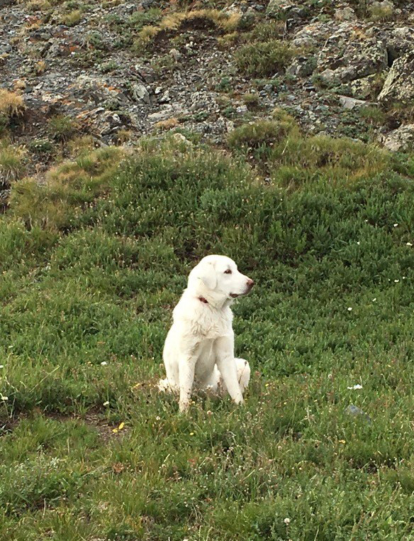
We heard the approaching herd before we saw it. In a matter of moments, our quiet campsite was invaded by several thousand bleating sheep, their bells ringing like a tour bus full of edgy Midwesterners emptying out into grizzly country for the first time. A single dark-skinned sheepherder watched from the ridge above as four sheepdogs worked the herd back and forth the formerly serene meadow. I’d encountered plenty of sheep in the Weminuche backcountry before, but the sheer size of this herd was something new.
I guess I’d always imagined that a moving herd of sheep would… you know, move. Like they’d have someplace to go and would be intent on getting there. In reality, there was very little forward progress, as successive waves of mutton surged around our tents and our cookstoves for well more than an hour. We’d think the herd was finally moving up the hill and over the ridge, but all of a sudden the sheep in the rear would turn around and surge towards us again. The dogs kept things orderly, but the shepherd made no effort to coax the sheep away from Stony Pass for the night.
Scanning the horizon for a hopeful break in the throng, I noticed an extended cab Tacoma parked just east of Stony Pass itself. Leaning against the truck was an older gentleman with his arms crossed, calmly watching the scene unfold. I wasn’t sure if he as a sightseer waiting to make his way east to Lake City or west to Silverton, a fellow hiker who identified with our predicament due to past experience, or someone somehow connected to the sheep operation. Whatever his business was, he just stood there watching us flail around in the sea of sheep. Admittedly, it was probably pretty entertaining.
As night began to fall, we were faced with a choice: stay where we had established camp and hope the sheep moved on (or at least didn’t trample our camp in the darkness), or move our tents to the next available spot we could see: a gravel pull-off about a third of a mile down the road. To complicate things further, the dark clouds to the west were becoming more organized and more menacing. Thunder sounded in the distance—it was almost certainly raining in Silverton already, and it was coming our way. We had to decide, and quickly.
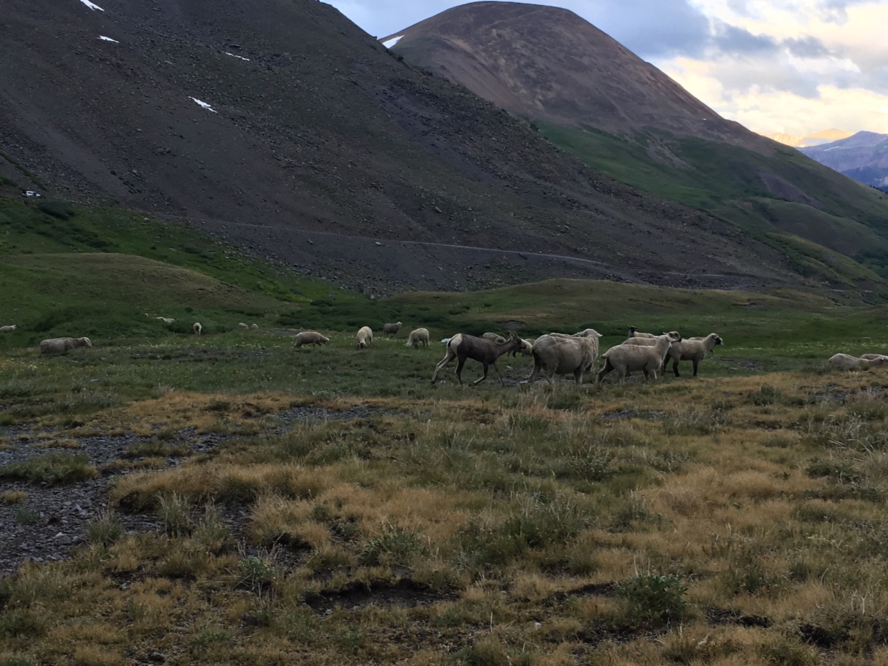
It was then that I noticed the bighorn. Among the throng of domesticated stock, one wild bighorn was trying to blend in with the herd. The whole thing was like a time-lapse sequence from a Benny Hill episode. Every time one of the sheep dogs noticed the bighorn, a chase would ensue. The wild sheep would easily outpace the canine and range out of sight, only to reappear once the dogs were preoccupied with other duties. I’d never witnessed a bighorn sheep commingling with a flock of their less wild cousins… but then again, I’d never been in the middle of a several thousand animal-strong herd. It was oddly compelling to watch. Of the photos I snapped with my phone, only one was clear enough to capture the whole scene.
Curiosity quickly gave way to practicality. I decided at last that I had no interest spending the night listening to the vocalizations of the sheep—or the constant sickening splats of sheep shit hitting the ground. At my urging, we very quickly broke down our tents, stuffed our gear in our backpacks and ran towards the possible other camp we’d seen. Rain was starting to fall, and I loathed the thought of re-pitching our tents in the middle of a Colorado summer squall.
Apparently, the shepherd had also decided that enough was enough. He shouted several commands to the dogs, who magically worked the herd and got them moving south up and over a ridge in a matter of minutes. As the bleating and the bells receded, shepherd then quickly made for the road. He reached the older man and his pickup just as the rain began to intensify. Both men jumped in the cab, the headlights gleamed and the engine came to life. They edged down from the top of the pass in the direction of Lake City.
As the truck reached us, it suddenly stopped. The driver jumped out and approached us, waving his Western hat as if to beat off the rain. “Sorry about that,” he said slowly. “I’d have had him bed down the sheep earlier if I’d known you were going to pack up and go.”
“That’s OK,” I replied wearily. I gestured towards the dark man in the passenger seat. “He was working,” I said, seeking some sort of way to bridge an obvious gap. “We’re just out here walking.”
“That’s true,” muttered the older man. He thought about it, then added strangely, “I am the pastor of this flock, after all.”
We waved a final curt goodbye and quickly made it to the gravel pullout just as the skies opened up. This second campsite was comparatively poor. Tent stakes did not willingly find purchase in the road base, and the slope of the pullout dictated that we pitch our ultralight shelters with their openings towards the incoming storm—a less than ideal situation. Lightning blazed trails through the dusk all around us as the rain soaked us, our half-pitched tents and all of our gear. Within about ten minutes we’d finished erecting our tents and crawled inside, but the damage was done. I’d spend much of the rest of the night futilely trying to contain the lake in the middle of my tent.
Wet and cold from the night’s trials, I found sleep elusive. I wondered about the old man, the shepherd and their Toyota. They could have moved the sheep at any time, making the driver’s quick apology ring less than true. I couldn’t shake the feeling that the way we’d been disrespected was a microcosm of the issues associated with high country land management. And I thought about that single bighorn who so badly wanted to join the flock that we so badly wanted to escape. What would come of her? Would they begrudgingly accept her, or would the dogs chase her off day after day? Did the sheep bosses even know she’d temporarily joined their herd?
Morning came slow and cold, and the usual coffee and granola had no power to improve our mood. We were on the trail by 6:30 with fifteen miles to cover. As we navigated across the headwaters of the Rio Grande between Canby Mountain to the west and Sheep Mountain to the east, our gear and our persons were soon dry. But our spirits remained dampened for the rest of the day.
Welcome to BenWanderin.com! I’ll be using this space to share thoughts, images and maps from my travels around the American West.
Content here will roughly fall into several categories: current reports from places I visit (either with my family, my friends or just myself), musings on remarkable trips from the past, and random thoughts about the current state of the West (with intrusions by politics, climate change and other subjects).
One thing you’ll notice is the use of embedded maps or satellite imagery in each post. During my time writing content for Colorado-based DigitalGlobe, I realized the power that geospatial imagery has to help readers more clearly visualize the interaction between people and place. So for example, the header image shown above was taken at the location shown in the Google map below.
Much more to come. Thanks for joining me on my wanderings!